News Roundup - August 2009
What follows is notable news and happenings that I want to purge from my bookmarks folder. It will be a combination of things you already know spiced with things you probably won’t care about. I apologize in advance.
GISVM is a set of free, open source set of virtual machines for GIS, including versions for both desktop and server. Software includes PostgreSQL, PostGIS, GRASS, GeoServer, MapServer, QGIS, gvSIG, uDIG, Deegree, R, and more. It uses Ubuntu Linux as the OS, and it’s a great way to try out and use a ton of FOSS GIS tools. Grab VirtualBox or VMWare Player and fire it up. Just be prepared to wait a while on the download - the desktop version with R and SAGA is 1.29GB zipped, and if there was a torrent link I didn’t see it.
Speaking of FOSS, a couple of things caught my attention this past month. The first is the explosion of development in the Linux kernel. Ars had an article summarizing the growth - 5 patches are now being accepted to the Linux kernel every hour. Over 1,000 developers participate in each kernel release. In a time when investments of any kind are down, Linux development is shooting through the roof. The other thing that caught my eye was this post by map butcher. The last time I gave an open source talk to a GIS group, I mentioned companies like ESRI used open source software, and I think I mentioned GDAL by name. map butcher lists them all out, and I was stunned at how much they use. I counted 58 different open source projects listed.
If you haven’t seen District 9 yet, stop reading this post immediately and go see it. Spatial Sustain linked to a District 9 web map/marketing site. The marketing folks for the movie are almost as good as the movie.
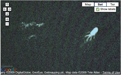
 Yes, that’s the Lock Ness Monster on Google Maps. At least that’s what some folks quoted at the Telegraph think. Sure, I know what you’re thinking. That’s obviously a boat and some wake. Plus, according to experts, climate change already killed old Nessie. I know the answer, but I’ll let you make up your own mind. Latitude 57°12’52.13”N, Longitude 4°34’14.16”W.
I’ve talked about the Ushahidi project before, which is a crisis monitoring tool using crowdsourced information. They’ve done a lot of really great work, including Alive in Baghdad. Now they’ve launched Alive in Afghanistan, which lets you view events Afghanistan as reported by the people there, largely via SMS. These folks do great work, and the site itself has a very intuitive map interface and date range/category selection tools. They use OpenLayers along with a Google base map. Spending 10 minutes on this site will give you more information about what’s going on in Afghanistan than watching 10 hours of your local 24 hour commercial news channel.
Finally, I’ll leave you with two maps for the month. The first is from BillShrink.com, and shows working hours around the world. You guys in South Korea are getting seriously screwed. Not that the US is doing all that great either - we’re on the high end. The Map Room links to the World Freedom Atlas, which has a dizzying amount of data for countries around the world relating to different aspects of freedom. There is so much information available you could spend an hour on the site and not touch everything. Whether you agree with all of the numbers or not, it’s one of the best and most useful sites of its kind that I’ve run across.
